
Save the Whales - Bellingham’s $40mm Padden Creek Joke
Map showing multi channel Padden Creek - with city planning denying two exist. .
Save the Whales - Bellingham’s $40mm Padden Creek Joke
Save the Whales - Bellingham’s $40mm Padden Creek Joke
Orca are an iconic species in the Pacific Northwest. Everyone wants to save them. The key to their survival is salmon. This truth applies equally to our indigenous fishers, and maybe all of us.
To accomplish this, Federal, State and Tribal priorities have led to the adoption of a broad policy framework for repairing the errors of the past to restore streams and salmon populations. The $2.8mm daylighting of Padden Creek is a poster child of this effort. With associated wetland restoration, this project came in at $9.5mm.
Now, another $31.25mm is being spent farther upstream to improve the channel for fish under Old Fairhaven Parkway (State Route 11) and Interstate 5. Taxpayers might hope that this project doesn’t include similar associated costs that inflate the final price by a factor of 3.4 times. At the projected combined total, it amounts to $450 for every man, woman and child in Bellingham. With overruns at the same ratio, it would come to about $1,300 each.
Meanwhile, downstream, it’s another story entirely. Granular city codes that a senior planner calls “tough to understand” and “created with built in flexibility” allow a developer’s project to encroach within 50 feet of a visible stream channel and numerous wetland species. Professionals hired by the developer denied these features, and so does the City. Setbacks were thus reduced and various other exceptions made, including any consideration of the Channel Migration Zone.
There is a bit of a row about this on NextDoor.

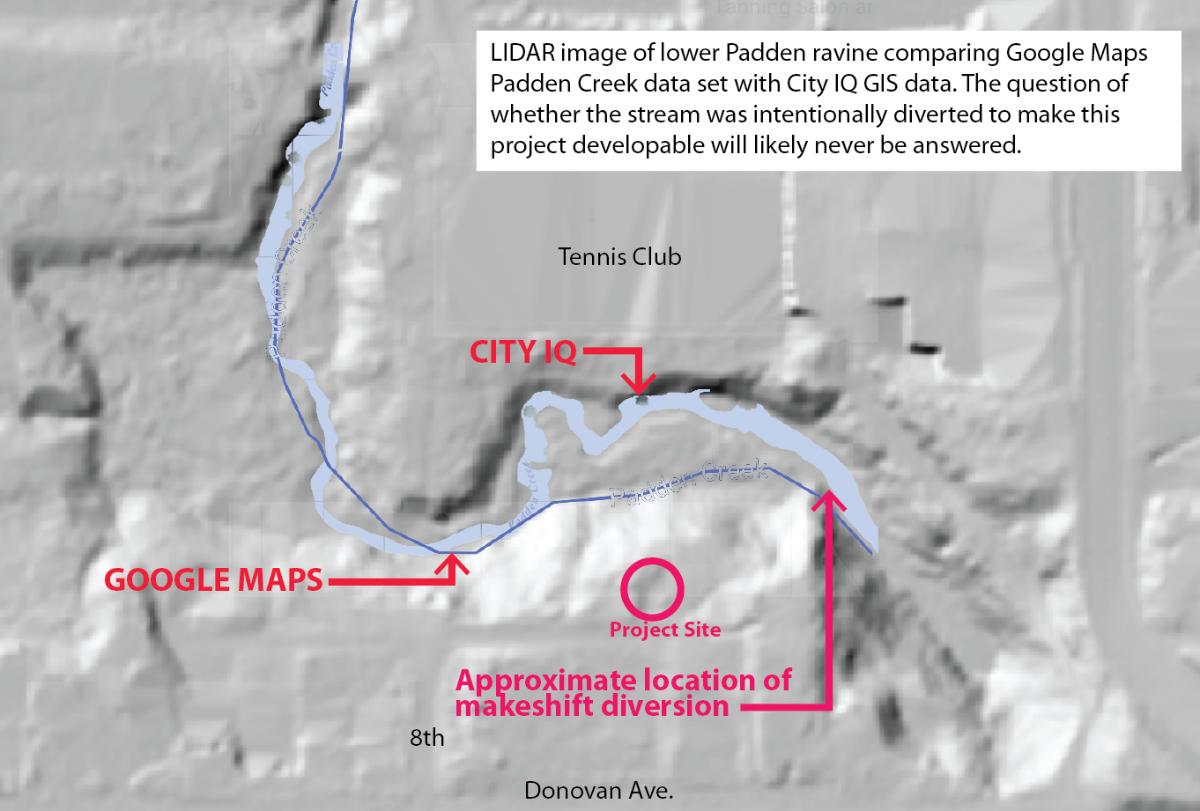
An interesting feature of the stream channel is that Google Maps’ data set show the stream in the unrecognized channel at the foot of the project, while the City’s GIS shows it running along the opposite side of the ravine. Even more suspiciously, at the point where the Google channel diverges from the existing channel, a makeshift dam comprised of an old culvert section shored up by stones appears to have been strategically placed to divert the stream farther away from the project.
These so-called “Townhouses” are in fact duplexes supposedly compliant with our Infill Toolkit - rules designed to “densify” our city. Nevermind that they are horribly out of character with the neighborhood. They will jut into the ravine and loom over it at their maximum allowable height, projecting noise and light into what is supposed to be a stream and wildlife buffer. And someone has already been busy in the buffer, posting no trespassing sign and manicuring the forest floor to a suburban standard.
No one should be surprised. Mayor Fleetwood ran on a platform of densification, citing the need to grow up, not out, and prophesizing that many thousands will come here to live. A review of his campaign materials shows concern over climate change and social issues, but not a word about neighborhoods. And this bent has born itself out with the bulldozing of character homes for infill apartments, the willingness to sell public property rights to add density to projects, the proliferation of podium style apartment blocks with no consideration of the needed public space, etc.
Many had hoped that we would grow with some foresight for beauty, public amenities and the cultivation of community. But it was not to be. Fleetwood kept every last one of previous mayor Linville’s pro-development staff. He is generally not to be heard weighing in on neighborhood concerns unless it is already done, or there is nothing to be done. This is the case here.
In a recent text to a concerned neighbor, the mayor said:
”… that pains me. I’ve not responded because I have felt utterly trapped… I stopped by on Monday and looked. It really, really sucks… I can’t stop it… I personally wish the entire Padden Creek riparian zone had been zoned long ago in a way that never would have allowed for this. I’m really sorry.”

And it is true. There was interest in protecting the Padden riparian zone. Greenways approved purchasing these properties, but no action was taken. The reason given by the Greenways Board (and frequently parroted by City staff) was “The land was unbuildable and wasn't in danger of being developed due to its dangerously steep slope, poor soil comprised of fill, and its close proximity to Padden Creek”. In zoning reviews this was also the party line. Even the Padden Creek Watershed Summary Sheet states that “… many small “paper plats” are located in the SMA, but their development is unlikely due to steep slopes and critical area setbacks. Undeveloped platted parcels are mostly located on steep slopes of Padden Creek ravine and their development is unlikely.”
Well, not unlikely enough.
This is a “death by a thousand cuts”, borrowing a phrase from Lynda Mapes, author and Environmental Reporter for the Seattle Times. She told me she sees it everywhere and it makes no sense. Mapes just published another book, “Orca: Shared Waters, Shared Home". So she’s actually been looking.
We had hoped for more from a supposedly progressive mayor. But we have no help. There is nothing to be done. We will continue being taxed to pay for premium streamway improvements, and developers will continue to profit by disrupting neighborhoods and encroaching on riparian functionality. In the end there will be no salmon and no orca. And the improved drainage - which has already eliminated a traditional flood plain in Happy Valley - will support continued development along our streams and open new development vistas in the upper reaches of the watershed. This project could well set a precedent for miles of property along this and other streams already subject to stricter setbacks.
It’s truly a bad joke, benefitting development at taxpayers’ expense… again.
Related is a 2018 statement by Drue Robinson who lives across the alley from this project. She has been trying to get the city to obey its own laws for several years.

5 Comments